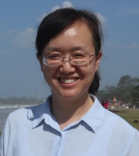
葛咏,女,1972年出生。中国科学院地理科学与资源研究所研究员,博士生导师,资源与环境国家重点实验室副主任,兼任地图学研究室主任。国家杰出青年科学基金获得者,长期从事地理空间统计学理论与方法研究。目前被聘为《Computers & Geosciences》副主编、《Spatial Statistics》编委和《地球信息科学学报》编委。兼任中国地理学会地图学与地理信息系统专委会主任委员和中国自然资源学会资源制图委员会专委会副主任委员。曾获国家和部委奖项4项。
学习与工作经历
2016.01 - 至今中国科学院地理科学与资源研究所,资源与环境信息系统国家重点实验室, 实验室副主任
2014.08 - 2015.12 中国科学院地理科学与资源研究所,地图学研究室,主任
2011.12 - 2014.07 中科院地理科学与资源研究所,资源与环境信息系统国家重点实验室, 研究员
2004.01 - 2011.11 中科院地理科学与资源研究所,资源与环境信息系统国家重点实验室,副研究员
2001.06 - 2003.12 中科院遥感应用研究所, 博士后
科研项目:
地理空间统计学方法,国家杰出青年基金(41725006), 2018.01 - 2022.12
全息地图数据获取与融合(2017YFB0503501),国家重点研发计划课题, 2017 .07 – 2021. 06
中国科学院战略性先导科技专项(A类)课题,六大经济走廊和关键节点的环境问题与风险识别及应对方案, 2018.06 – 2022.12
学术任职
2019 中国地理学会,地图学与地理信息系统专委会主任委员
2018 《Computers and Geosciences》副主编,
2014 《地球信息科学学报》编委
2011 《Spatial Statistics》(SCI)编委
代表著作
Ge, Y., Jin, Y., Stein, A., Chen, Y., Wang, J., Wang, J., Cheng, Q., Bai, H., Liu, M., and Atkinson, P. M.: Principles and methods of scaling geospatial Earth science data, Earth-Science Reviews, 197, 10.1016/j.earscirev.2019.102897, 2019.
Ge, Y., Hu, S., Ren, Z., Jia, Y., Wang, J., Liu, M., Zhang, D., Zhao, W., Luo, Y., Fu, Y., Bai, H., and Chen, Y.: Mapping annual land use changes in China's poverty-stricken areas from 2013 to 2018, Remote Sensing of Environment, 232, 10.1016/j.rse.2019.111285, 2019.
Ge, Y., Yuan, Y., Hu, S., Ren, Z., and Wu, Y.: Space-time variability analysis of poverty alleviation performance in China's poverty-stricken areas, Spatial Statistics, 21, 460-474, 10.1016/j.spasta.2017.02.010, 2017.
Ge, Y., Chen, Y., Stein, A., Li, S., and Hu, J.: Enhanced subpixel mapping with spatial distribution patterns of geographical objects, IEEE Transactions on Geoscience and Remote Sensing, 1-15, 10.1109/TGRS.2015.2499790, 2016.
Ge, Y., Wang, J. H., Heuvelink, G. B. M., Jin, R., Li, X., and Wang, J. F.: Sampling design optimization of a wireless sensor network for monitoring ecohydrological processes in the Babao River basin, China, International Journal of Geographical Information Science, 29, 92-110, 10.1080/13658816.2014.948446, 2015.
Ge, Y., Liang, Y., Wang, J., Zhao, Q., and Li, S.: Upscaling sensible heat fluxes with area-to-area regression kriging, IEEE Geoscience and Remote Sensing Letters, 12, 656-660, 10.1109/LGRS.2014.2355871, 2015.
Ge, Y., Chen, Y., Li, S., and Jiang, Y.: Vectorial boundary-based sub-pixel mapping method for remote-sensing imagery, International Journal of Remote Sensing, 35, 1756-1768, 10.1080/01431161.2014.882034, 2014.
Ge, Y., Avitabile, V., Heuvelink, G. B. M., Wang, J., and Herold, M.: Fusion of pan-tropical biomass maps using weighted averaging and regional calibration data, International Journal of Applied Earth Observation and Geoinformation, 31, 13-24, 10.1016/j.jag.2014.02.011, 2014.
Ge, Y.: Sub-pixel land-cover mapping with improved fraction images upon multiple-point simulation, International Journal of Applied Earth Observation and Geoinformation, 22, 115-126, 10.1016/j.jag.2012.04.013, 2013.
Ge, Y., and Bai, H.: Multiple-point simulation-based method for extraction of objects with spatial structure from remotely sensed imagery, International Journal of Remote Sensing, 32, 2311-2335, 10.1080/01431161003698278, 2011.
Ge, Y., Li, S., Lakhan, V. C., and Lucieer, A.: Exploring uncertainty in remotely sensed data with parallel coordinate plots, International Journal of Applied Earth Observation and Geoinformation, 11, 413-422, 10.1016/j.jag.2009.08.004, 2009.
Ge, Y., Li, S., and Lakhan, V.: Development and testing of a subpixel mapping algorithm, IEEE Transactions on Geoscience and Remote Sensing, 47, 2155-2164, 10.1109/TGRS.2008.2010863, 2009.
Ge, Y., Bai, H., Cao, F., Li, S., Feng, X., and Li, D.: Rough set-derived measures in image classification accuracy assessment, International Journal of Remote Sensing, 30, 5323-5344, 10.1080/01431160903131026, 2009.
版权所有 © 长安大学土地工程学院 地址:中国西安市南二环路中段 邮箱:tdyb@chd.edu.cn
邮编:710064 技术支持:泽瑞通信